Ever Green Nature
A meek endeavor to survey nature & wild animals. Protect Nature That will protect you
Wayanad is situated at the height varying from 700-2100m above mean sea level in
How to reach
The nearest airport is Calicut.The district is well connected by a railway network.Wayanad's Headquarters, Kalpetta is linked by road to other towns in Kerala and there are frequent buses to
Rail:
Road
Wayanad Wildlife Sanctuary: The discriminating tourist can have an insight into the ethnic culture evocative of earlier centuries. Trekking is also undertaken by travelers. Wildlife enthusiasts and natural world lovers would be awed by the wildlife sanctuaries of Wayanad. The Wayanad wildlife sanctuary at Muthanga was established in 1973. The sanctuary is an integral part of the 'Nilgiri Biosphere Reserve', established for conserving the biological heritage of the region. The sanctuary is about 344 sq.km in extent. One part is at Tholpetty near Manathavady, which is contiguous with Nagarhole of Karnataka. The other is Muthanga Bathery Kurichiat range, which is nearer to Sulthan Bathery bordering Mudumalai forests of Tamilnadu and Bandipur of Karnataka.Muthanga has numerous watering holes and houses a large population of pachyderms. It has been declared as a 'Project Elephant' site. Jungle cats, panthers, civet cat, monkeys, wild dogs, deer, spotted bears, bison, gaurs, cheetah, wild bears are seen here. The reserve is also a home to a small population of tigers. Wayanad is often called 'the land of spices'. Coffee, black pepper, ginger, turmeric, cocoa, arecanut, tea, rubber, vanilla and other crops are grown here. Trees such as rosewood, Artocarpus, Erthrina, and several species of caussia are still preserved in the Wayanad region. These trees give shade to the coffee plants. The silver oak which is much suited to the cold climate grows quickly in this area and it gives support to pepper. Eucalyptus also grows in plenty in Wayanad hills. Tea is grown on commercial basis as an industry in large estates in Wayanad. There are also teak plantations in major reserve forests. The soil and climate of Wayanad is suitable for horticulture, which is also cultivated on commercial basis. Vegetables and orchards are also being raised. Amidst the fertile flora, this region hosts several rare herbs and medicinal plants.
Thirunelli Temple:
The shrine is shielded with 30 granite columns and the ground is paved with huge square pieces of granite. The crystal clear waters of the Papanasini river running downhill add to the enchantment of the place.
The
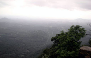
Lakkidi : Lakkidi, the gateway of Wayanad, is situated 700 m above mean sea level, at the crest of the Thamaraserri ghat pass. Haughty peaks, splashing streams and luxuriant forests add magic to the journey up the winding roads to this hill station of kerala. One of the highest locations in Wayanad, Lakkidi also commands picturesque scenery. It is about 58 kms. north east of
Vythiri:Vythiri is a beautiful place located in the dense thickets of the hilly ranges of Kerala. Popular for its refreshing and pollution free air, this place is a must visit as an excursion from Wayanad.
Banasura Dam: 15 kms
Sentinel Rockfall:Near Chooralmala, about 22 kms south of Kalpetta, it is a rivetting waterfall tumbling down a height of 20 m from a hilltop. The spot is ideal for rock climbing.
Pazhassi tomb  :(32 km northeast of Kalpetta): The memorial of the 'Lion of Kerala' - Veera Pazhassi Raja - who organised the guerilla warfare against the British East India Company, is situated at Mananthavady.The Pulpally cave is where Pazhassi took refuge until he was captured by the British.The Glass Temple of Kottamunda (20 km away from Kalpetta): This temple is located on the slope of Vellarimala and is dedicated to Parswanatha Swamy of the Jain faith. The mirrors inside the temple walls reflect images of the icons in the temple's sanctum sanctorum.
Boys town:(15 km north of Mananthavady): Herbal garden, nature care centre, sericulture unit, perma-culture centre etc., established by the Wayanad Social Service Society and Jean Park (the Indo-Danish project for promoting herbal gardening) are situated here.
Pakshipathalam:(10 km from Thirunelly): This place can be accessed only by trekking. Rare species of birds can be sighted from the watch tower of this bird sanctuary. Pakshipathalam in the Brahmagiri hills at Thirunelli is a challenging tourist spot for any adventure seeking tourist. To reach Pakshipathalam, seventeen kms have to be covered through wild forest. The deep rock caves, formed among the thick blocks of rocks at the northern top end of the Brahmagiri, are the abode of various birds and wild beasts. Special permissions have to be obtained from Forest Department to go to Pakshipathalam. District Tourism Promotion Council arranges vehicles, guides, camping equipments, etc. to the tourists, on here. This scenic bird watching spot is located 1740 meters above sea level. It is an ideal place for trekking and bird watching. The undulating hills look absolutely gorgeous with steep sides, streams and unexplored forests
Kuruvadweep: The Kuruva Island, 950 acres of evergreen forest on the tributary of east following river Kabani, is an ideal picnic spot, far away from the trouble of city life. The island is unoccupied. Rare species of birds, orchids and herbs are the sovereigns of this supernal kingdom. It is 17 kms. east of Mananthavady and 40 kms. North West of Sulthan Bathery It is a perfect picnic spot on an uninhabited island on eastern part of Kabani river.
 :Situated at a height of 2100 meters above sea level near the lofty ranges of the

Muthanga Wild Life Sanctuary:Muthanga, which is 16 kms. east of Sulthan Bathery, is located very near to the Karnataka border. Wild forests covering an area of 345 sq.kms. from the Muthanga Wild Life Sanctuary; the biggest abode of wild animals in Malabar. Elephant, spotted deer, bison, tiger, cheetah, wild bear, etc. are found in this sanctuary. The Forest Department has facilities for providing elephant rides and trekking to tourists he
Kanthanpura waterfalls:Kanthanpura waterfalls or Kanthapura waterfalls: This beautiful waterfall is about 30 mts in height.

Soochippara Waterfall: The waterfalls at Soochippara near Meppadi are really a treasure of nature, yet to be discovered. The stretches of waterfalls ranging at places from 100 to 300 feet height are a treat to the eyes. The pool below provides for water rafting, swimming, bathing, etc. The tree top huts at Soochippara give a unique view of the valleys of the
Mananthavady:Mananthavady: This place lies 32 kms from Kalpetta and has a historic church which is of tourist interest. Designed in Kerala style with gabled roofs, there are some interesting tombstones in the church ground
Phantom Rock:Phantom Rock: This rock resembles a skull shape and is locally known as Cheengeri Mala.
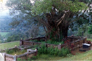
Chain Tree: Chain Tree: This Ficus tree which is very large is bound by a prominent chain and it is approximately 15 kms from Kalpetta.
Place Distance from Kalpetta
Ambalavayal Farm 25 kms
Banasura Sagar Dam 21 kms
Banasura Sagar Hills 29 kms
Begur wild life sanctuary 52 kms
Chain tree 15 kms
Cheengeri hills 23 kms
Cheeyambam waterfalls 37 kms
Chembra peak 15 kms
Edakkal cave 27 kms
Jain temple (Sulthan Bathery) 24 kms
Kanthanpara waterfalls 18 kms
Kappikalam waterfalls 24 kms
Karapuzha Dam Site 16 kms
Karland chira 15 kms
Kuruva island 35 kms
Mananthavady Pazhassi Tomb 34 kms
Meenmutti Waterfalls 29 kms
Muthangadi 23 kms
Muthanga wild life sanctuary 39 kms
Pallikunnu church 14 kms
Pakshipathalam 72 kms
Pazhassi Tourist Resort 33 kms
Papanasini 66 kms
Ponkuzhi 41 kms
Pookot lake 13 kms
Puliyarmala 3 kms
Pulpally Sitadevi temple 34 kms
Soochippara waterfalls 22 kms
Tholpetty wild life sanctuary 52 kms
Thirunelli temple 65 kms
Trikaipatta temple 11 kms
Varampatta mosque 22 kms
Valliyoorkavu temple 31 kms
Distance to Major Tourist Centres from Kalpetta
Udagamandalam (Ooty) 115 kms
Coorg 80 kms
Thiruvananthapuram 497 kms
To Know more about wayanad Please go to
http://www.kerelatourism.com/wayanad.html
http://www.kerala-travel-tours.com/kerala_india_cities/wayanad_travel_tourism.html
Labels: Kerala tourism


